<< Continued From Map Reading 101: Cuts, Benches, Dips, and Gullies
Map Reading 101: Cuts, Benches, Dips, and Gullies
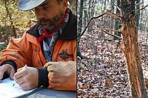
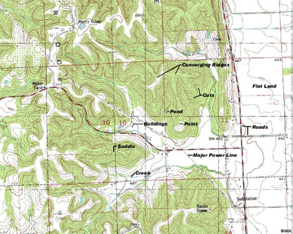 With 2 roads, 2 buildings, a power line, pond, creek, point, 2 converging ridges, 2 cuts, a saddle labeled and flat land labeled, study these features and find other examples on this topo map. |
Another good topographical funnel are dry washes (cuts) running down the side of the ridge. Here, years of focused runoff have caused the ground to erode to the point where cuts occur in the side of the ridge. Once they erode to a certain point, they become difficult for deer to cross. To avoid doing so, many deer will either go up the ridge to cross at the upper tip of the cut or will go down to cross at the bottom.
When these cuts are deep enough to discourage crossing and go far enough up the ridge they can be great stand sites. Sitting above the top of the cut can result in covering the traffic around the tip, along with the buck trail common to the upper edge of the ridge and the family group’s ridge top trail. Towards the bottom of the cut, where the runoff begins fanning and the cut dissipates, can also produce good stand sites.
A cut is easily identified on a quad map by the contours V-ing into the side of the ridge, as they go up the side. In general, the narrower and more pronounced the V is the shaper and steeper the sides of the cut are. Conversely, the more the series of contours each resemble a U, the more tapered the cut. However, these cuts are still worth investigating and are often sharper than the map reveals.
Another potentially good stand site is where several cuts come together near the bottom of hill or ridge sides. Because deer tend to follow these cuts up and down, the convergence of cuts can create a busy intersection of deer trails. Stands placed along the side hills, above where the cuts converge, are good bets. However, because swirling winds are the rule in these locations, only those that take odor control very seriously should attempt to hunt them.
Benches are yet another funnel and can be one of the best stands for rutting bucks there is. In a nutshell, a bench is a fairly flat strip of ground that runs along the side of a ridge, located somewhere around half way up the side of the ridge.
A common occurrence in ridge country is to have farm crops planted in valleys that are flanked by wooded ridges on either side. In this setting, the deer often bed high and feed low. Under these conditions, when a bench runs along the side of a ridge, a buck can scent check the trail of every doe that’s recently transitioned between feeding and bedding. Because of that, along with these flat areas being easier walking than the steep sides of the ridge, benches often become highways for cruising bucks.
As with every other topographical feature, a bench shows up on our contour map. When looking at the stacked contours along the side of the ridge, keep an eye pealed for a gap somewhere around half way up the ridge. Remember, tightly stacked contours show steep raises in elevation. When a gap appears between contours that are tightly stacked above and below it, you have a bench. Furthermore, the longer it snakes its way along the side of the ridge the more productive the bench will likely be.
When it comes to funnels involving ridges, many of the very best are where two of these features converge. As was the case with the stand location at the beginning of this chapter, a good example is when a sharp cut begins near the base of a saddle. Here, the hunter can intercept bucks running the top of the ridge, those crossing at the saddle and the ones skirting the cut.
Flat land hunters also have the potential to find topographical funnels. Deer like to maintain low profiles. Doing so increases their life expectancy. Because of that, they will commonly travel any dips or gullies that keep them hidden. Finding these low profile areas on contour maps can identify areas that deer use as travel routes. They can be discovered by looking for areas where contour maps make Us as they meander through flatter areas.
As you can see, having the ability to read topo maps can provide tremendous advantages in finding stand sites, as well as keeping scouting and hunting impact at a minimum. The more one studies these maps the better they become and more potential stand sites emerge.
To help build these skills, simply print off a topo map of your hunting land and put it to use during an off season scout. When you come across topographical features, find them on the map and note how the contours appear. After no time at all, the features will begin making sense. Trust me, if you get nothing else from this book, the minimal effort it takes to learn how to read topo maps will pay for itself countless times over.
Courtesy Steve Bartylla
Want To Know More?
Bowhunting Tactics That Deliver Trophies ($30) and Advanced Stand Hunting Strategies ($22.50) delve deeply into critical details you must address to consistently arrow the big boys. For an autographed copy ($50 when ordered together), send a check or money order (shipping & handling already is included) to:
Steve Bartylla
1406 St Joseph Ave
Marshfield, WI 54449
Include your name and shipping address.