When I first started taking trips out of state to chase whitetails, I dreamed of coming home to Michigan with one of those giant bucks you see on the cover of magazines. After a few trips and finding some success, I quickly realized the real trophies are the memories made in different places with family and friends. These adventures and memories have a far greater impact than any inches of antler. Of course, who doesn’t want to get a crack at a big mature buck?
Outsmarting a big old buck on public land is one of the biggest challenges in hunting, and who doesn’t love a good challenge? However, the realization that so much land open to public hunting exists in our great country is what continues to drive me to invest time, gas and money for a tag and expose myself to new, amazing experiences year after year.
Preparing for an out-of-state public land whitetail trip can be daunting. I’m a bit of a planner by nature, which has proved advantageous over the years when it comes to hunting outside my home state. You can have a great plan and prepare for anything, but the willingness to adapt and throw your original plan right out the window at any moment is crucial. In other words, it’s important not to pigeonhole yourself into limited possibilities, especially if your initial approach isn’t yielding opportunities.
Cast a Wide Net
The beauty of the internet is that you only need to know the name of the state you’re interested in hunting. From there, with a couple of searches, you can bring yourself up to speed quickly on opportunities that align best with your goals and schedule.
Start by doing a Google search for hunting seasons and regulations for whichever state you’re interested in hunting. Obviously, the first step is to determine if tags are available to nonresidents over-the-counter or if a certain amount of preference points are needed to obtain a tag successfully. A highly sought after state like Iowa, for example, will typically require 2-4 years of preference points before actually drawing a tag, whereas states such as Nebraska are available over-the-counter to nonresidents.
After you’ve researched how and when to obtain your tag, the next step is understanding the season dates. Knowing dates provides a look at the season in its entirety, compare it to your available schedule, and when you feel your best odds are of seeing the most deer in daylight.
The rut is often a popular choice for many deer hunter’s trips across the country. It offers the highest likelihood of catching bucks on their feet in daylight, especially in areas you may not hunt throughout the year or have a history of understanding movement patterns in detail. The rut, despite some claims, happens close to the same time every year in a respective area. If this is the time frame you are focusing your trip around, researching and learning when the rut occurs in the area is critical. Then you can cross-reference this for the stage of the rut you would like to focus on and correlating weather conditions that look favorable to deer movement.
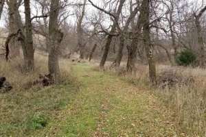
Once you’ve determined the date range you want to hunt, it’s time to home in on the region, county(s) or area(s) you want to hunt. Many states limit nonresident tags to specific counties, units, areas, etc. Make sure you fully understand the details and limitations of your deer tag. From here, I like to start dialing in on a more defined area by using an aerial map. I start by locating rivers and creek systems. These areas usually offer a variation, even if it’s slight, of habitat types. If rivers and creeks are present, these are usually the areas where the best security cover and structure is located. Other benefits are a water source for deer, as well as desirable forage. Next, I look for a concentration of tillable land. These areas commonly serve as destination food sources for one or multiple deer herds in an area.
Give Yourself Options
Advancements in technology have changed the game for hunting. We now have endless amounts of information and maps at our fingertips with the development of websites and mobile apps. Tools such as interactive maps and state wildlife websites make it easier than ever for hunters to identify opportunities and create an adventure of their choosing by a few clicks of a mouse or taps on a phone screen. It’s impossible to overstate the value of these resources and how vital they are in creating a plan for the area you want to hunt.
Some hunt-focused mobile mapping apps like OnX and HuntStand even help hunters by offering a filter that identifies locations and details about land open to public hunting in an area. Create a hit list of tracts that hold what you’re looking for in a hunting location. Remember to identify different options for most likely deer movement for different times of day, as well as various wind directions.
Every situation and location is unique, but over the years, I’ve noticed trends in my approach to public land hunting trips regardless of region or state. The most prevalent: I like to have at least 10 different tracts identified to scout and/or hunt. This number can vary depending on the size of the individual properties.
I try to break up larger tracts into smaller sections that I can scout or hunt down, identifying the best portions of each tract and focusing my efforts there. Typically, I end up hunting only a few of these until I either kill or narrow down the options to the best two or three. The main reason I have so many options is that I approach a trip with the strategy of going to where the deer are and not hunting where I think they should be or hope they’ll be. Whether it’s the rut, food source selection, or whatever the cause, finding where the deer are currently located is pivotal to a hunt on a deadline. With a finite amount of time, you can’t afford to put all your eggs in one basket right away, hoping sooner or later a buck comes by. It’s imperative to stay mobile, continuing to scout until you find the spot.
Don’t fall victim to missing the often overlooked spots, either. Just because there might be only one corner on a piece of land that is public, and at first glance on a map it looks marginal at best, it’s worth checking out on foot. It could be the best tract in the whole section. Take the time to speed scout these little out of the way spots for fresh sign and buck activity. Look at the larger picture as well. A huge travel corridor can be entirely on private except for a 10-acre parcel that extends onto a piece of public that otherwise would be a wide-open pasture. Sometimes these little gems are all it takes to hold a good buck and can be excellent cruising funnels during the rut. If your first thought about a spot is that it doesn’t offer enough to be worth your time, check it out anyway. Chances are other hunters are likely thinking the same, and pressure could be low, which means an attractive spot to locate a mature public land buck.

Scout, Scout, Hunt
The more I hunt public land, regardless of the region or state, the more I find myself scouting rather than hunting. When the season is in, it’s technically all hunting, but I’m referring to less time in an actual tree and more time on the move or behind glass. When I’m on an out-of-state trip, no matter where it is or how many times I’ve hunted the area, I spend at least the first morning driving around glassing multiple public spots as well as bordering properties. On more than one occasion, I have spotted a buck I wanted to shoot doing this and immediately narrowed my focus to a parcel or two.
For some perspective, if I’m on a hunting trip for 7 days, I commonly spend at least the first 2 days of the trip scouting. Being efficient with the limited time you have is incredibly important. The windshield time is valuable to understanding the location of attractive crops. Look for cows, too, because they can significantly affect how deer use the property. Even things like checking low-maintenance roads for accessibility. If there’s been a lot of rain recently and some dirt roads may be impassable, eliminating some public areas from your list. These may seem like nuances but can have a significant impact on how deer use property and your ability to hunt them.
Taking scouting a step further to do a quick cruise through the tracts is essential as well. On a public piece I hunt in Kansas, I learned after a few seasons that the crop rotation greatly impacted the amount of use a draw of timber was getting from bucks. When it was beans or wheat, the activity in November was sparse, with only a few rubs and scrapes. On years when it was corn or milo, though, it was shredded with rubs and clusters of large scrapes throughout the draw. Speed scouting tracts like these help save time and can help get you in to the action more quickly.

Gain Inside Information
At this point, hopefully, you’ve done a bunch of research on the web, studied areal and topo maps at length, and possibly even gone out for a scouting trip to the location you plan on hunting. One of the most overlooked resources available to everyone is the Department of Natural Resources office for the area. It’s time to start burning up the phone lines. In this non-verbal communication age we are living in, it’s tempting to rely strictly on what chat forums, Google results and information you find online, but I strongly urge you to make a few calls. Yes, the internet is a valuable resource. Don’t stop there though, follow up all that information with actual conversations with people who can give you real insight. It’s incredible the amount of valuable information a 15-minute phone call can produce, both on where and where not to hunt.
As I mentioned, Iowa has been a highly sought-after destination for whitetail addicts for decades. The state manages the populations and hunting regulations well. The limited amount of nonresident tags helps with hunting pressure and keeps age structures on the higher end of the spectrum. Here’s the kicker: The land available to public hunting is in the ballpark of two percent of the state, a low number compared to many other states in the country. With limited options available on public land, taking the time to talk with conservation officers in a state like Iowa can pay off huge.
It’s no secret that a southeast Iowa archery tag is highly coveted. It’s pricey and takes multiple years of preference points to draw. It’s been several years since I’ve cashed in points and drawn a tag, but the last time I hunted it, I wanted to make the most of the trip. I took a trip in early spring to scout a few locations and spent hours poring over areal and topo maps. Although this was all time well spent, one of the most beneficial things I did was make a couple calls to the DNR office in the area I wanted to hunt. The first call didn’t get me far, but the second was exceptionally helpful. On both calls, I spoke with officers who were friendly and willing to help.
The second officer I spoke with was a passionate bowhunter himself and understood the type of experience I wanted. We traded a few hunting stories and he was helpful with pointing me in the right direction. He identified a few areas that don’t get much pressure, as well as portions of pressured tracts that often get overlooked. Even though I didn’t fill my tag on the pieces of public ground he mentioned to me, I did have a few high-quality hunts and saw a couple of mature bucks. Ultimately, his advice helped me focus on a few key areas that I may not have discovered otherwise.
Remember, conservation officers are there to help, and we’re on the same side. The only time you should be nervous or disappointed to cross paths with one is if you are doing something you shouldn’t be doing.

Keep Perspective
If you take the time to sit and think about taking an out of state trip and all it entails, it’s a reasonably tall task. Going to a different state or region you aren’t used to hunting, spending a week or two, sometimes less, trying to hunt down a big buck on land that’s available to everyone else is asking a lot. Keep your expectations and goals in check.
If your goal is a mature buck, understand the odds are against you, and the likelihood of coming home with your tag still in your pocket is a strong possibility. There’s nothing wrong with that outcome either, especially when you’re hunting your hunt. If your goal is to go out, fill the freezer and take the first legal buck you encounter, do it with pride and feel great about the fact that you’ve done something extremely difficult that many hunters never take the chance or make the investment of time and money it takes.
Make it about experiences and memories, not about big bucks. Enjoy the journey, embrace the struggle. It’s the struggles and hard-fought seasons we remember most. Come back with exciting stories and a big smile of accomplishment from seeing different landscapes and all they provided. If you come back with some antlers and meat for the table, well, that’s a bonus to the real success you experienced.