Featured Photo: Knockdown Outdoors
I still remember clutching a Langlade County, Wisconsin, plat book for the first time. It detailed land ownership for every single parcel in the entire county. I thought I’d won the lottery. I now had the resources to determine who owned what, so I could contact landowners and ask for hunting permission. Beyond that, the plat book listed all lands open to the public for hunting, including state- and DNR-owned lands and managed forest land open (MFLO) lands.
I was barely a teenager and just wetting my feet in the whitetail woods when I acquired that plat book, but it proved beneficial because I always found places to hunt. Soon after adding the plat book to my hunting arsenal, I learned of aerial imagery and topo maps. Today, the same information for my county can be obtained for free online via the county’s geographic information system (GIS), which offers layers and multiple viewing options.
The problem with the aforementioned tools is they weren't very convenient. So I scaled back my use of everything except the plat book … until the smartphone arrived.
Determine your needs
Consider the area(s) you hunt and how you hunt, then decide what will produce the best results for your individual situation. For example, if you belong to a hunting club or lease, you'll have different needs than those who hunt on public lands. Likewise, an outfitter has far different needs than someone who owns a 40-acre parcel they hunt themselves.
Keep in mind a hunting apps central benefit: organize data and keeping it at your fingertips for on-the-go convenience.
With that in mind, here are a few hunting apps that might be just what you're looking for.
onXmaps
Perhaps the most popular app in the hunting community is the onXmaps Hunt app. To begin, it turns your smartphone into a plat book by showing land ownership. The app also features layers, which include public and private lands, possible land-access routes, 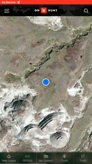 hunting units, section lines, game-species data and points of interest. These layers can be adjusted based on preferences.
The onX Hunt app also offers drawing and shape tools, as well as the ability to mark waypoints and your location. You might assume all of this requires 4G or LTE coverage? Nope. With a Wi-Fi or data connection, you can download and save maps within the app so that you can access them in the “Off-Grid” tab when using the app offline. So, without data coverage, your saved maps will still show your location and all other features noted above. For that reason, I recommend getting a smartphone with a high storage capacity, as each map you save is several hundred megabytes in size.
Other ways this app's features apply to hunting:
- You get the obvious aerial-image capabilities but, with all of the land-ownership data, you can identify properties open to public hunting.
- You can mark stand locations and create access routes to follow, making accessing stands easier. Maybe even without a flashlight.
- Once you hang a stand or place a blind, the track-and-record feature will tell you how long it took you to reach your truck, the distance and your speed. When you return to hunt, you’ll know exactly when you must leave your truck in order to reach your stand before daylight.
- If you have to blood-trail an animal onto privately-owned land, the app makes it easier to identify the property's owner, make contact and gain permission to track and recover the animal.
- This also proves beneficial if you’re hard up for hunting spots and need to knock on some doors.
For more information, visit www.onxmaps.com.
Knockdown Outdoors
If you’re an outfitter, guide, property manager or member of a lease or hunting club, Knockdown Outdoors offers the app for you. With it, you can manage multiple hunting properties, marking features like stands or blinds, feeders, cabins or any other important aspects 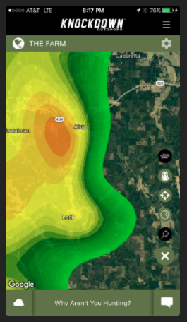 of your properties. Then, you can share any property with other Knockdown users who’ll be hunting it. Once the property is shared, users with access can get an aerial view with the features you’ve marked.
Other ways this app's features apply to hunting:
- Knockdown Outdoors users can check in and out of stand locations, chat with other members of the property, share photos, swap hunting activity, view the property’s past harvest statistics and obtain minute-by-minute weather data.
- In fact, the app even offers wind and radar overlays.
- The Knockdown Outdoors app is just $2.99 per month or $29.99 annually, and it virtually pays for itself because it simplifies the entire hunting and property-management experience.
- This app also works without an Internet connection.
- While I haven’t used this app for whitetails, I did use it while guiding turkey hunters for an outfitter in central Florida. The ability to share properties with all of the features shown on the map simplifies everything — no need to take self-sufficient clients to their hunting locations.
- Kevin Knighton of Backwoods Life, a TV show that airs on a few outdoor networks including the Sportsman Channel, is a huge Knockdown Outdoors advocate. “Knockdown Outdoors is my go-to hunting app because it has everything in one place,” Knighton said. “Wind forecasts, radar, distance measurement; it’s all available in seconds. Plus, my friends and I can chat within the app, reserve hunting spots on our lease, check in/out, and never accidentally walk in on someone else's hunting spot for the day. Best of all, it’s ad-free.”
For more information, visit www.knockdownoutdoors.com.
Google Earth
At the bare minimum, every whitetail hunter should have Google Earth on their smartphone. The ability to gain a bird’s-eye view of a property while afield is indispensable. I mean, why drive home and view it on a computer when you can do it on the go? T
he best part? It’s free. 3-D views also help users access a potential hunting property's topography. Sure, burning boot rubber is always necessary, but you can cut down on intrusion and disturbance by using Google Earth more and walking less.
For more information, visit www.google.com/earth.
ScoutLook Hunting
ScoutLook Hunting is another contender in the map-based app world. Hunters who hunt the wind at all costs, in particular, will find this app incredibly beneficial. In the app, users can save thousands of hunting locations. This makes it easy to review possible stands 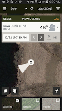 to hunt once you’ve studied the conditions: temperature, cloud cover, barometric pressure, wind activity, sunrise and sunset times, moon phase and radar overlay.
Other ways this app's features apply to hunting:
- Available maps are satellite, topographic and street-view.
- The app's Scent-Cone feature denotes where your scent will blow at each hunting location over a 72-hour period.
- Users can save ideal wind directions for each stand and a color-coded feature will help you choose ideal stands for the forecasted wind conditions.
- ScoutMarX lets users mark trails, parking areas, campsites, food plots, deer sign, and blood trails. Additionally you can log game activities and movements to pattern deer or other game you're pursuing.
- You can manage hunting properties by allowing hunters to view property details. These users can can contribute game-activity logs with a secure property access code.
For more information, visit www.scoutlookweather.com/hunting/scoutmap
Bonus: The scoop on GIS
Many states offer a GIS on their wildlife-department websites. These versions show all public-accessible areas, including privately-owned lands enrolled in programs such as Walk-In Hunting.
When researching an out-of-state hunt, I use the GIS mapping system extensively to determine how many acres of public-land hunting exist near a town where I can lodge during the hunt. When you click on the outlined lands, it usually states the likely species that exist on the respective parcel, as well as what dates it’s open to hunting and how many acres it is. You’ve heard me refer to these sorts of features throughout the article as “tools,” and they truly are. I think many folks want ways to make killing a buck easier. If you find a way, sign me up.
With the recent influx of hunting pressure, killing a big buck is a tall order. But the tools we use and — more importantly how we use them — works to simplify our hunting strategy and boost hunting success.